Florida Wildlife Corridor

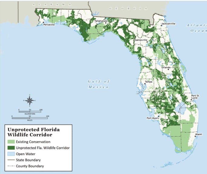
A nearly 18-million-acre natural necklace of connected lands and waters comprises the Florida Wildlife Corridor. It weaves through our state supporting wildlife, natural and prime agricultural land, and recreational opportunities for residents and visitors alike, and provides essential ecosystem services that filter and cleanse our drinking water, sequester carbon, absorb floodwaters, and so much more. The Florida Wildlife Corridor and the many services it provides are essential to our state’s long-term environmental health and economic prosperity
With about 90% of all Floridians living within 20 miles of the Corridor, its resources benefit us all. Almost 8 million acres remain unprotected and are vulnerable to development. We can’t acquire them all, nor should we want to, so what can we do now to make a difference? Sound planning is another tool in the toolbox.

SEE THE BROADCASTS!
The University of Florida Center for Landscape Conservation Planning and 1000 Friends of Florida have partnered on a series of 8 2-hour presentations on a host of planning strategies to conserve Florida’s natural and agricultural lands and promote sustainable and compatible development patterns in urban areas. Check out the broadcasts.

MIND THE GAPS
The Florida Wildlife Corridor Foundation and 1000 Friends of Florida are partnering on an online curriculum to “Mind the Gaps” to protect specific geographic areas within the Corridor. One module will be geared to elected officials and community stakeholders, and the second will focus on planning practitioners. See what is coming soon!
Find Out More About the Florida Wildlife Corridor
FEGN Dashboard
Geared to community stakeholders, these interactive statewide and county GIS maps show existing and potential conservation lands and reveal how they could be impacted by future development.
FEGN Online Map Viewer
This viewer may be used by GIS practitioners to develop science-based plans and policies at the state, regional, and local levels in Florida.
FIND OUT MORE ABOUT THE FLORIDA WILDLIFE CORRIDOR
The FEGN Dashboard includes general overview GIS maps.
The FEGN Online Map Viewer includes detailed GIS data.
Past Planning to Protect the Florida Wildlife Corridor
Broadcasts and PowerPoints
A series of leaders share community planning and land conservation strategies to protect the Corridor. Check out their presentations:
Looking at the Big Picture
What is the Florida Wildlife Corridor, and why is landscape-scale conservation essential for its future?
Fostering Community Vision
What regional efforts are protecting Florida’s natural and agricultural lands through sound community planning?
The Planning Toolbox
Learn about the strengths and weaknesses of myriad planning tools available to promote healthy communities and rural lands in Florida.
Building a Big Tent
How do the economics of development impact Florida’s rural lands, and how can we forge partnerships between agricultural interests, conservationists, landowners, elected officials, and others to protect the Corridor?


