County Maps
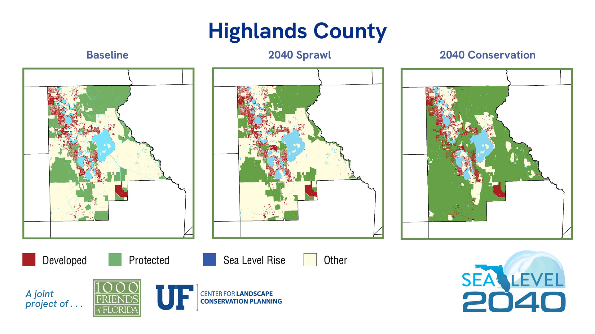
Highlands County
Sea Level 2040:
Baseline
2040 Sprawl
2040 Conservation
Baseline
2040 Sprawl
2040 Conservation
| 2019 | % of Total Acreage | Sprawl 2040 | % of Total Acreage | Conservation 2040 | % of Total Acreage | |
|---|---|---|---|---|---|---|
| Developed | 60,367 | 8.53% | 62,658 | 8.85% | 62,305 | 8.80% |
| Protected Natural Land | 101,326 | 14.31% | 101,326 | 14.31% | 149,133 | 21.07% |
| Protected Agriculture | 94,127 | 13.30% | 94,127 | 13.30% | 309,073 | 43.66% |
| Agriculture | 315,925 | 44.63% | 314,175 | 44.38% | 99,540 | 14.06% |
| Other* | 82,479 | 11.65% | 81,938 | 11.58% | 34,173 | 4.83% |
| 2019 Open Water | 53,634 | 7.58% | 53,634 | 7.58% | 53,634 | 7.58% |
| Sea Level Inundation: Protected Lands | 0 | 0.00% | 0 | 0.00% | 0 | 0.00% |
| Sea Level Inundation: All Other Land Uses | 0 | 0.00% | 0 | 0.00% | 0 | 0.00% |
| Total Acreage | 707,858 | 100.00% | 707,858 | 100.00% | 707,858 | 100.00% |
| Total Land Acreage | 654,224 | 92.42% | 654,224 | 92.42% | 654,224 | 92.42% |
| Total Open Water including SLR | 53,634 | 7.58% | 53,634 | 7.58% | 53,634 | 7.58% |
Population
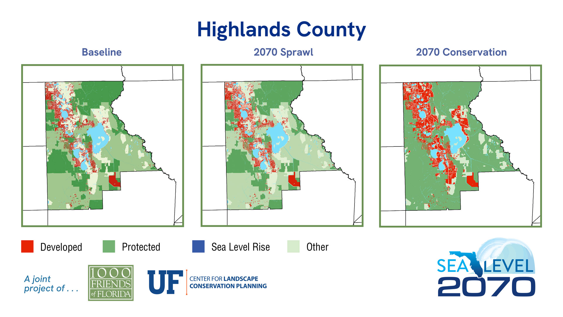
Sea Level 2070:
Baseline
2070 Sprawl
2070 Conservation
| 2019 | % of Total Acreage | Sprawl 2070 | % of Total Acreage | Conservation 2070 | % of Total Acreage | |
|---|---|---|---|---|---|---|
| Developed | 60,367 | 8.53% | 78,358 | 11.07% | 119,219 | 16.84% |
| Protected Natural Land | 101,326 | 14.31% | 101,326 | 14.31% | 149,133 | 21.07% |
| Protected Agriculture | 94,127 | 13.30% | 94,127 | 13.30% | 305,512 | 43.16% |
| Agriculture | 315,925 | 44.63% | 302,469 | 42.73% | 55,344 | 7.82% |
| Other* | 82,479 | 11.65% | 77,944 | 11.01% | 25,016 | 3.53% |
| 2019 Open Water | 53,634 | 7.58% | 53,634 | 7.58% | 53,634 | 7.58% |
| Sea Level Inundation: Protected Lands | 0 | 0.00% | 0 | 0.00% | 0 | 0.00% |
| Sea Level Inundation: All Other Land Uses | 0 | 0.00% | 0 | 0.00% | 0 | 0.00% |
| Total Acreage | 707,858 | 100.00% | 707,858 | 100.00% | 707,858 | 100.00% |
| Total Land Acreage | 654,224 | 92.42% | 654,224 | 92.42% | 654,224 | 92.42% |
| Total Open Water including SLR | 53,634 | 7.58% | 53,634 | 7.58% | 53,634 | 7.58% |


